WildTrax
See, Hear, Know
WildTrax is an online platform for storing, managing, processing, and sharing data collected by environmental sensors such as autonomous recording units (ARUs), remote cameras, and point counts.
What is WildTrax ?
With the advent of new environmental sensors to collect biological data, the rate and volume of data accumulation is unprecedented. The increasing use of environmental sensors has brought the challenges of ‘big data’ to the foreground of wildlife monitoring. WildTrax is an environmental data platform that simplifies the processing, organization, storage, and sharing of large and small environmental data sets.
WildTrax began as a solution to a home-grown problem. Since 2013 the ABMI, University of Alberta, and various partners amassed large volumes of data through the use of three initial sensors: remote cameras, ARUs, and point count data, which capture images of wildlife and record wildlife sounds. At 10 million images and half a petabyte (or 75 continuous years) of recordings and counting, data management has become an essential component of our programs. To use these data most effectively, we developed WildTrax.
What can WildTrax do for you?
Users can establish organizations, create projects, upload data, process data, and manage data through their WildTrax account. The core functions that WildTrax supports are storage, data and user management, processing, sharing, and discovery of WildTrax data.
The WildTrax platform is available for widespread use and offers an array of continuously improving tools to help in all aspects of working with sensor data. We continue to invest in research and development, particularly in the application of machine learning to develop auto-recognition software, to increase data processing efficiency and accuracy, and to provide other value-added data interpretation tools. These tools are released through the WildTrax platform for all users and organizations to use for their big data needs.
WildTrax also supports discovery of data by providing a data-discovery mapping interface that allows for spatial exploration and download of publicly available data. Researchers, land managers, and monitoring agencies can delve into publicly available data within their region of interest and identify opportunities to work with others who are actively using sensors for wildlife monitoring.

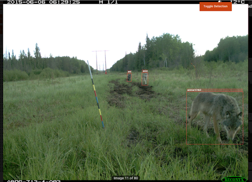
An example of Microsoft’s Megadetector in use on WildTrax.
Data Security and Privacy
WildTrax is set up to allow for flexibility when it comes to data privacy. Data security and privacy can be managed at both the organization and project levels. An overview of the privacy structure can be found in Wildtrax's Terms and Conditions of Use.
Development
The WildTrax team is continually implementing various features and functionalities to further develop the platform and support user needs. Please review our Development Phases for more information.
Creating an account and setting up an organization and projects are free. Exceptions may occur when there are multiple terabytes of media being uploaded by a single organization (10’s of millions of images / years of ARU recordings), in which case there may be some required cost recovery for the storage fees. For any reasonably sized research project, WildTrax is free.
We do offer additional “full-service” options for those preferring active support with their data. Contact info@wildtrax.ca for information on these options and other services related to your long-term, big-data storage needs.

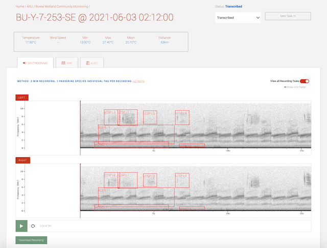
Autonomous recording unit features

1. Create an online account.
2. Create an organization or join one for which you’ve been granted access by the owner.
3. Create (a) project(s) within your organization or participate in a project to which you’ve been added.
4. Upload data yourself or ship the data to WildTrax staff for uploading.
5. Process your image or sound data within the online interfaces.
6. Download, review, or share your data any time, anywhere.
If you simply want to discover data that is already available, go to the Data Discovery portal.
Sponsors
- Environment and Climate Change Canada
- University of Alberta
- Canada's Oil Sands Innovation Alliance
- Alberta Environment and Protected Areas (EPA)
- Joint Oil Sands Monitoring Programming
- Innotech Alberta
- University of Alberta Sound Studies Institute
- Natural Sciences and Engineering Research Council of Canada
- PTAC
Partners
- Environment and Climate Change Canada
- Alberta Environment and Protected Areas
- Devon
- ConocoPhillips
- Cenvous Energy
- Nexen
- Imperial
- Shell
- Suncor Energy
- Alberta-Pacific Forest Industries Inc.
- Canadian Natural
- Alberta Conservation Association
- Parks Canada
- University of Alberta
- Government of Saskatchewan
- Sahtu Renewable Resources Board
- Regional Industry Caribou Collaboration
- Canadian Mountain Network
- Boreal Avian Modelling Project
