.jpg)
Confidentiality and Data Usage
The ABMI’s site confidentiality policy exists to ensure the scientific integrity of sites we visit multiple times and to protect the privacy of landholders in Alberta.
Exact site coordinates are not released without landholder approval.
In 2021 we updated our policy to enable research and collaboration while still upholding landowner confidentiality agreements. We established three categories of confidentiality status for our sites:
Open: Open status applies to sites we plan to visit only once. These site locations and their species and habitat data can be directly downloaded from our website data portal by anyone.
Controlled: Controlled status applies to sites we are planning to revisit, where the land manager (for private and public land) has given permission to share the location. Information on these locations is only released to approved individuals after completing an access request (e.g., types of research that will not manipulate or alter the site).
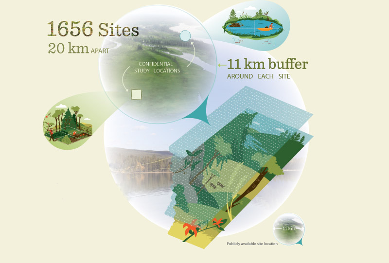
Restricted: Restricted status applies to sites where the exact site location will not be released. Instead, the ABMI uses a “hazed buffer" measuring 11 km in diameter (approximately the size of one township). The monitoring site falls at a random point within the 11 km buffer. The centrepoint of the buffer is used as our public site location. This allows data users to link biodiversity information with a general area to ensure the data is useful, without giving away the exact location of our monitoring sites.

Confidentiality and Data Usage
Read about accessing our data, data usage, and how we maintain trust.

Accessing Data
- In order to access exact site locations, the site must have a status of open or controlled.
- For controlled sites, a request must be submitted to abmiinfo@ualberta.ca with a completed Project Description Form. Please note that not all requests will be approved.
- For open sites, data are associated with the exact coordinates in our Open Data Portal. Note that the biological data collected at the ABMI sites is always available through our Open Data Portal.
- Submitting the above form requests access to exact coordinates for controlled sites to link to the biological data rather than the buffered locations.
- The ABMI will not release exact site locations without landowner approval.
- The ABMI is not a management agency, nor does it make management decisions.
- Maintaining site location and landholder confidentiality is essential to the ABMI’s monitoring work.
- Establishing trustworthy and open relationships with landholders is essential to ensuring the ABMI will be able to return to sites to measure changes over time.


Data collected by the ABMI are publicly available on our website and in our reports. The ABMI’s goal is to monitor and report on changes in Alberta’s biodiversity with unbiased, scientifically credible data. We do not make land management decisions or recommendations for sites.
Scientists and researchers, teachers, land managers, provincial planners, or any interested person may download data and use it to (for example):
- Learn about the distribution of a species across Alberta,
- Discover how human land use has changed over time, and
- Measure changes in biodiversity to ensure land management goals are being met.
The data are also used at the ABMI in applied research projects. Learn more under Projects and Collaborations.
